Authors
J. Larmarange, R. Vallo, S. Yaro, P. Msellati, N. Méda, B. Ferry
Abstract
Backgrounds
Since 2001, several Demographic and Health Surveys (DHS) include HIV testing. We developed a generic approach to map spatial trends of HIV prevalence from DHS (free software online). We present how our results from Burkina Faso 2003 DHS shed new light on HIV epidemics.
Methods
An estimation is made of regional spatial trends of HIV prevalence for each surveyed cluster by aggregating data from neighbouring clusters, using rings of the same number of tested persons and taking into account main urban agglomerations. The map is then generated by spatial interpolation.
Results
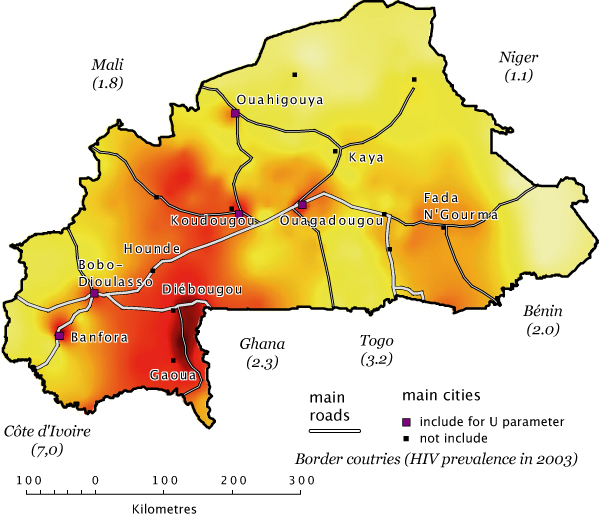
This map is coherent with the knowledge we had of HIV epidemic in this country. Prevalence is higher in main cities and small cities along main roads.
The region around Diébougou and Gaoua was particularly affected, a data which had not shown on antenatal surveillance. In addition to its proximity to Ivory Coast and Ghana, it is a major gold-washing zone which also has lot of migrant men and sex workers.
The map showed similarities with migration areas in the 80’s and 90’s and with repatriate returns from Ivory Coast at the end of 2002 and beginning of 2003.
Lastly, our results diverge from antenatal surveillance around Kaya. The high prevalence observed in this rural clinic is not representative of the low prevalence at a regional level.
Conclusion
HIV prevalence mapping highlights differences that were not visible using antenatal surveillance ; allows identifying most prevalent areas ; constitutes a monitoring and evaluation tool ; and suggest new research fields to investigate.